
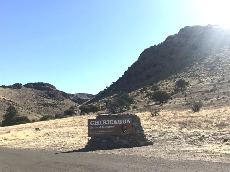
About 90 minutes northeast of Bisbee, Arizona, lies a hidden wonderland that completely took my breath away: Chiricahua National Monument.
To be honest, I didn’t do much research before arriving, so I had no idea what to expect. As someone who deeply loves exploring National Parks and Monuments, I knew I’d enjoy it regardless of what was there. However, stumbling upon massive rock pinnacles and lush forests hidden high within the rugged desert landscape was something I never could have anticipated.
If you are planning a trip to the Southwest, Chiricahua National Monument hiking needs to be at the very top of your bucket list. Here is what it’s like to tackle one of the most breathtaking trails in the park.
Planning the Ultimate Chiricahua National Monument Hiking Itinerary
Upon arriving, our first stop was the visitor center. We were greeted by a friendly park ranger who highly recommended the “Big Loop”—a comprehensive 9.5-mile trek that covers almost all of the park’s major highlights.
Typically, a 6-to-7-mile hike is my comfort zone. However, looking out at the unique landscape, I knew I didn’t want to miss a single thing. We decided to go for it.
Our Modified “Big Loop” Trail Route
To help you navigate, here is the exact counter-clockwise route we took:
- Echo Canyon Trail (Starting point)
- Upper Rhyolite Canyon Trail
- Sara Deming Trail
- Heart of the Rocks Loop (We hiked this portion clockwise)
- Big Balanced Rock Trail
- Mushroom Rock Trail
- Ed Riggs Trail (Bringing us back to the start)
Pro Tip: We chose to skip the detours to Inspiration Point, which brought our total distance down to about 8.6 miles.
We completed the entire loop in about 5.5 hours, which included a relaxed lunch break, chatting with fellow hikers, and stopping frequently to catch our breath and snap photos.
On the Trail: What to Expect on the Big Loop
We drove up to the Echo Canyon parking lot to begin our adventure. The wind at the trailhead was strong and cool, forcing us to layer up, grab our gear, and hit the path.
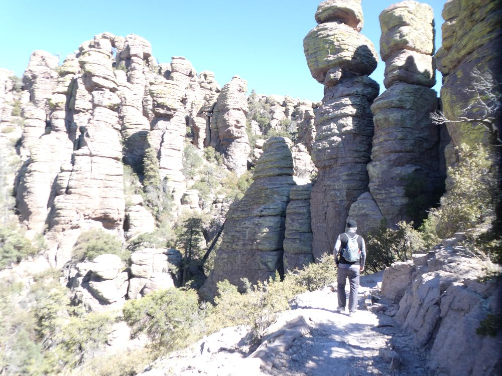
Descending into the Grottos and Rhyolite Pinnacles
The trail started off beautifully, gently descending along a well-maintained path. Our first major landmark was “The Grottos.” Because it was quite crowded with other visitors, we decided to keep moving rather than linger.
Before long, the park’s famous rhyolite rock pinnacles began to appear everywhere, towering over us like ancient stone sentinels.
A Surprising Desert Forest
As we neared the bottom of the canyon descent, the scenery shifted dramatically. The arid desert faded into a lush, forest-like environment.
As we began our slow ascent, the dense tree cover provided some much-needed shade, making the uphill climb incredibly enjoyable and cool.
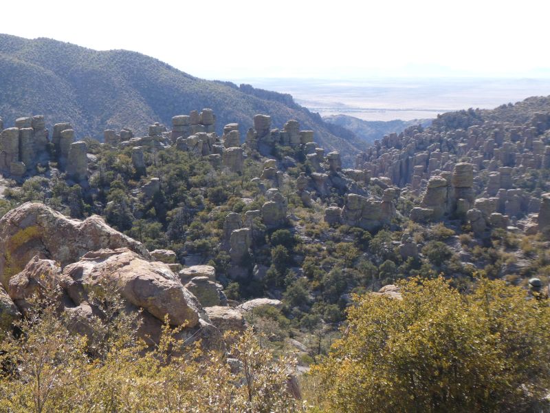
Navigating the Heart of the Rocks Loop
For me, the Heart of the Rocks Loop was the most physically demanding portion of the day. Some of the stone steps were quite high, and by the time we reached it, we were exactly 4.3 miles in—meaning we still had 4.3 miles left to go. Hunger and fatigue were starting to set in.
However, pushing through was worth every single step. The unique rock formations inside the Heart of the Rocks loop are nothing short of spectacular. Adding that extra 1.1-mile loop is non-negotiable if you want the full Chiricahua experience.
After completing the loop, the final 3.3 miles of the trek were mostly exposed to the sun, making us grateful we brought plenty of water.
A Quick Stop at Massai Point
After finishing our grueling but rewarding 8.6-mile hike, we hopped back in the car and drove a bit further up the scenic road to Massai Point.
If you don’t have the time or endurance for a massive hike, Massai Point offers an effortless, quick peek at the expansive canyon views and balancing rocks from above. It was the perfect finale to our day.
Park Amenities and Trail Conditions
The National Park Service does a truly fantastic job maintaining this hidden gem.
- Trail Signs: The markers are large and very clearly display the names of the intersecting trails, directional arrows, and mileage. Note: They are light in color to blend in with the natural environment, which means they can occasionally be a bit tough to read in direct, glaring sunlight.
- Facilities: The restrooms at the visitor center were absolutely spotless.
- Trail Maintenance: Every single trail we stepped on was beautifully cleared and well-maintained.
Chiricahua National Monument completely blew me away. Whether you are looking for an intense day-hike or just a scenic drive through Arizona’s history, this park deserves a spot on your travel itinerary.
The National Park Service did a great job with their trail marker signs. They were large very clearly marking the names of the trails with directional arrows as well as miles, although light in color to blend with the view, sometimes a little hard to read with the sun. Additionally, the visitor center rest room was spotless, and the trails were all very well maintained.
Helpful Resources for Your Trip
Read more about our adventures from this trip:
- A 30-Day Southwest Road Trip Itinerary: Bisbee, Flagstaff, & Kanab
- Flagstaff & Beyond: Ancient Ruins, Route 66, and Desert Wonders
- 12 Days in Bisbee, Arizona: Quirky Charm & Epic Day Trips
- 8 Awesome Things to Do in Kanab, Utah
- Peekaboo Slot Canyon: Our Thrilling UTV Adventure Into the Red Desert
- Dinosaur Tracks, Moqui Caverns & Belly of the Dragon Hikes