
A short but packed stop in Northern Arizona and Southern Utah—where 900-year-old cliff dwellings, a legendary Route 66 town, one unforgettable song, and some of the Southwest’s most surreal geology made our road trip come alive.
Flagstaff was a fantastic home base for us—really just two full days of exploring, sandwiched by two travel days that turned out to be adventures of their own. From the towering ponderosa pines of the Colorado Plateau to the red sand of Utah, Northern Arizona absolutely delivered. Let’s get into it.
Quick Trip Overview
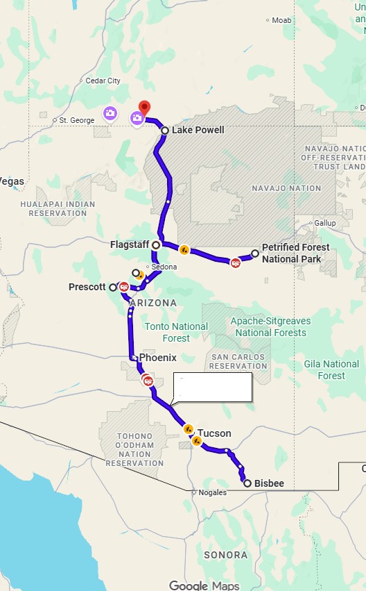
| Day | Route & Key Stops | Highlights |
| Day 1 | Bisbee to Flagstaff | Prescott breakfast, Sedona crowds, Petrified Forest, Winslow corner |
| Day 2 | Flagstaff Local | Continental Country Club driving range, Downtown brewery hopping |
| Day 3 | Verde Valley Loop | Tuzigoot National Monument, Route 66 to Williams, craft beer |
| Day 4 | Flagstaff to Kanab, UT | Walnut Canyon, Horseshoe Bend, Toadstool Hoodoos |
Day 1 (Travel Day) Prescott, Sedona & the Petrified Forest
A Breakfast Stop in Prescott
The drive from Bisbee to Flagstaff is roughly five hours, and we broke it up with a stop in Prescott to visit a family member for breakfast. Prescott is a genuinely charming high-desert town — historic courthouse square, Victorian architecture, a lively Whiskey Row. A lovely midpoint on a long drive.
Leaving town, the stretch through Coconino National Forest was stunning—towering ponderosa pines, volcanic peaks in the distance, and that dramatic shift in elevation as you climb onto the Colorado Plateau.
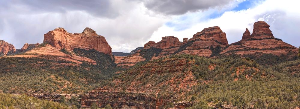
The Sedona Situation
After Prescott we passed through Sedona, and here’s the short version: it did not go well.
We had planned on a hike and lunch, but the traffic was unlike anything we expected. Finding a parking spot felt like a competitive sport. We tried three separate trailheads—zero luck. We eventually scored one questionable spot, had a quick beer (no food), and bailed.
We later found out we hit the absolute peak of Sedona’s spring tourist season, right as pandemic-era travel restrictions were easing. Major choke points had formed all along State Route 179 and through “The Y” intersection. Needless to say, we were hangry and grumpy for a bit. It happens!
Tip: If you’re planning to stop in Sedona, go early in the morning or on a weekday, and look into booking a shuttle or parking in advance. It is stunning, but it is popular for a reason.
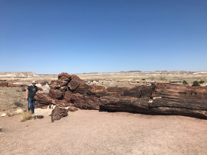
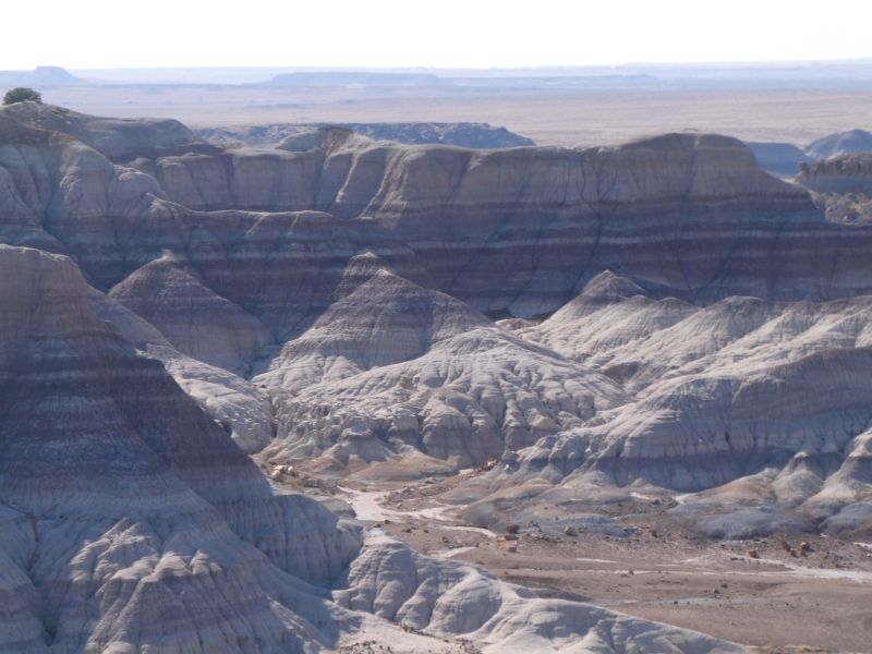
Petrified Forest National Park — Late Afternoon
Since Sedona didn’t work out, we used the extra hours to knock out Petrified Forest National Park (originally scheduled for the next day).
By the time we arrived, it was late afternoon. Because we hadn’t reviewed our trail maps the night before, we weren’t fully prepared for the layout. We walked the Giant Logs Trail, but soon realized the park’s visual landscape shifts dramatically depending on where you look.
The Petrified Forest is a bucket-list concept: an ancient landscape where trees that fell 225 million years ago slowly turned to crystal-laced stone, scattered across a painted desert. What’s preserved right near the road is remarkable, but you need to know how to pace it.
Front-load your energy: Most of the striking, massive fossil concentrations are located near the southern entrance (like the Crystal Forest and Giant Logs Trail).
The Middle Stretch: Once you pass the main fossil sites, the route becomes much more of a panoramic scenic drive through open desert badlands. Make sure to pull off at Blue Mesa to see the surreal, banded blue and purple hills.
Good to know The park road is about 28 miles one way, but plan for at least a half day or a full day if you want to do it justice.
Winslow, Arizona — Standing on a Corner
We made sure to swing through Winslow on the way to Flagstaff that evening — because how do you drive through northern Arizona and not stand on that corner?
If you’re not a classic rock person: the Eagles’ 1972 song “Take It Easy” opens with the line about standing on a corner in Winslow, Arizona. The town has leaned into it fully, and honestly, it’s charming. There’s a bronze statue, a flatbed Ford mural, the whole thing.
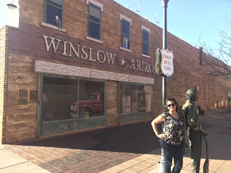
Beyond the song, Winslow was a lovely surprise. It’s a small Route 66 town with real character that doesn’t feel overly commercialized. We had a great dinner here which completely turned our evening around.
Worth a stop: Take a walk through the La Posada Hotel. Even if you aren’t staying the night, this beautifully restored 1930 Harvey House is filled with incredible history and art.
Day 2: A Flagstaff Day — Breweries & a Driving Range
With a massive travel day behind us, we spent a relaxed day exploring Flagstaff on foot.
Continental Country Club Driving Range
We hit the driving range on the north side of town, and the backdrop alone made it memorable. Standing on the grass with Humphreys Peak—the highest point in Arizona at 12,637 feet—looming directly behind the target flags is incredible. Plus, at 7,000 feet of elevation, your golf balls fly noticeably farther.
Flagstaff’s Walkable Craft Beer Scene
Flagstaff punches well above its weight class for craft beer, and downtown is compact enough to hop between spots seamlessly.
Dark Sky Brewing was our first stop — named in honor of Flagstaff’s status as the world’s first International Dark Sky City (the city actively limits light pollution to protect stargazing). They’ve brewed over 500 different recipes and keep a creative, rotating tap list that covers everything from hazy IPAs to barrel-aged sours. It’s a small operation with big ambitions and consistently excellent beer.


From there we wandered to Flagstaff Brewing Company, one of the oldest brewpubs in the city, open since 1994. It sits right on Route 66 — casual, unpretentious, the kind of place where locals and travelers mix easily. A great spot to settle in, order a pint, and let things slow down.
Day 3: Tuzigoot, Route 66 & Williams
This was a day that completely floored us with an unexpected mix of ancient history and Americana.
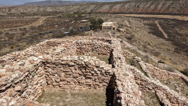
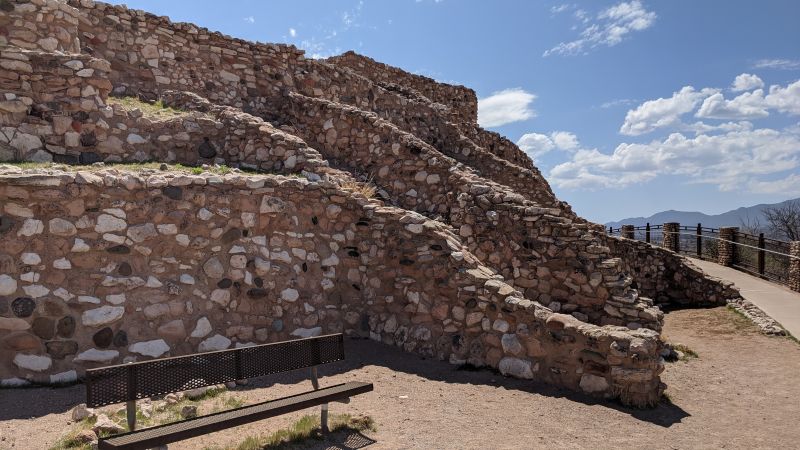
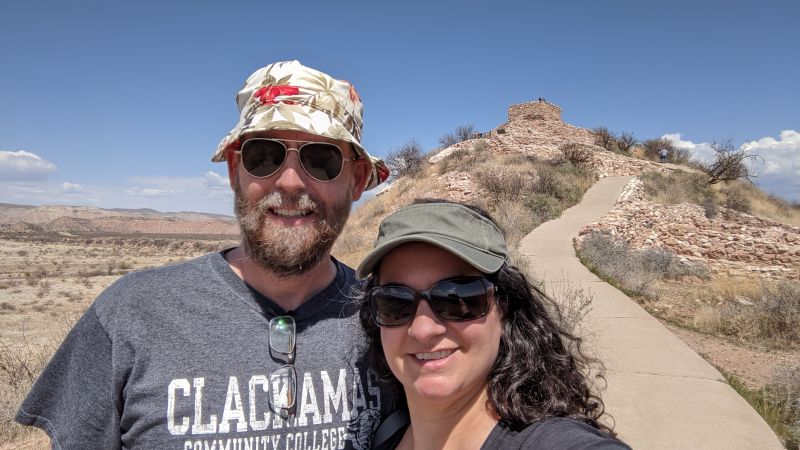
Tuzigoot National Monument
Drive time: About 90 minutes southwest of Flagstaff
Built by the Sinagua people — a pre-Columbian culture whose name translates to “mountains without water” — Tuzigoot National Monument sits on a limestone ridge rising 120 feet above the Verde Valley.
What you’re looking at is a massive hilltop pueblo with over 110 rooms, originally standing two and three stories high, built between 1000 and 1400 CE. Standing at the top of the ruins, you immediately see the strategic strategy behind the location. The views of the Verde River valley are completely sweeping.
Standing at the top of the ruins and looking out over the Verde River valley, you immediately understand why they chose this location. The views are sweeping and strategic — you can see for miles in every direction, with the valley floor, the river, and distant mountain ranges all laid out below you. The walls are built from limestone and sandstone, whatever was most available, and the construction is remarkably preserved after 900 years.
What makes Tuzigoot fascinating is the trade network. Archaeologists found macaw bones from deep inside Mexico and sea shells from coastal California. Yet, by the 15th century, the inhabitants completely vanished from the site, leaving a beautiful mystery behind.
The on-site museum is excellent and worth your time before walking the ruins. It displays pottery, tools, and artifacts that give real texture to what daily life looked like here.
Money Saving Tip: Your Tuzigoot entry fee also covers Montezuma Castle National Monument nearby.
Route 66 to Williams, AZ
After the ruins, we drove west on Route 66 to Williams, AZ — famous for being the very last Route 66 town bypassed by the interstate in 1984. It sits right at the crossroads of the historic highway and the train route to the Grand Canyon South Rim. It has a fantastic, well-worn energy filled with neon signs and historic storefronts.
Williams is also home base for Grand Canyon Brewing Company, a family-owned operation that started here and has since expanded to Flagstaff. Their beers are inspired by the landscapes of northern Arizona — adventurous, outdoorsy in spirit, and solid across the board.
Back in Flagstaff that evening, we ended at Historic Brewing Barrel & Bottle House — a standout. Historic Brewing has been around since 2013 and has built a reputation for creative, slightly unconventional beers. Their downtown Barrel & Bottle House is their most polished space, with craft cocktails alongside the taps and a proper pub vibe. A fitting cap to a day that ran from ancient ruins to Route 66 to a barstool.
Day 4: Travel Day to Kanab, UT with stops at Walnut Canyon, Navajo Bridge, Horseshoe Bend & the Toadstool Hoodoos
Our travel day north to Kanab turned into an absolute highlight reel of three completely distinct landscapes.
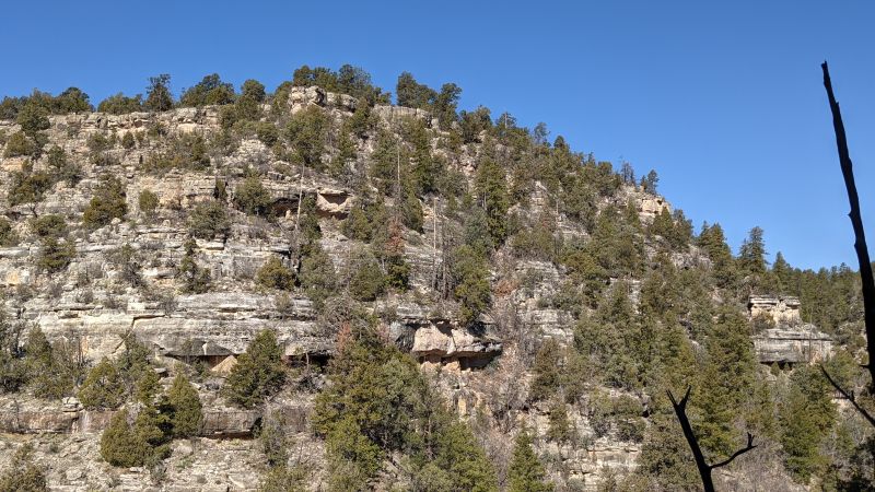
Walnut Canyon National Monument
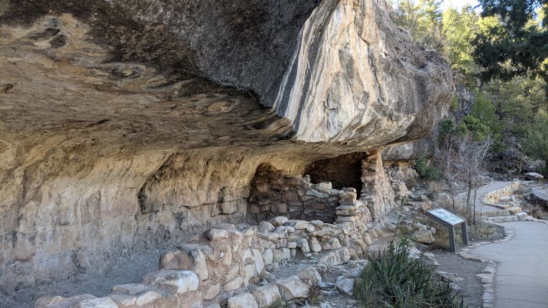
Just 7 miles to the east of Flagstaff off I-40, Walnut Canyon National Monument is the perfect morning stop before heading north. While Tuzigoot sits high on a ridge commanding the valley, Walnut Canyon does the opposite. The Sinagua built into the canyon walls, tucking their homes into shallow limestone alcoves beneath massive overhanging ledges.
The canyon is 400 feet deep, and as you walk the Island Trail, you pass right in front of 25 visible cliff dwellings. Standing beneath those natural rock overhangs—which served as ancient built-in climate control—is humbling. Interestingly, historians note that Walnut Canyon actually contained more total rooms (300+) than the famous Cliff Palace at Mesa Verde (approx 150).
It was a perfect way to ease into what would be a long drive north — something that made us slow down, look closely, and feel genuinely connected to the landscape we were passing through.
The ruins are incredible. Elaborate and humbling in equal measure.
Note: The Island Trail involves a steep 240-step descent into the canyon (and back up!). It’s short, but you absolutely need real shoes with good grip.

A Surprise Encounter at Navajo Bridge
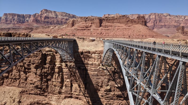
Before Horseshoe Bend, we made a stop at Navajo Bridge—a breathtaking double-span structure stretching nearly 500 feet over the sheer walls of Marble Canyon and the Colorado River. Walking across the historic 1929 pedestrian bridge is a thrill in itself as you are 470 feet above the river, but the real magic is looking down into the steel rafters. When it became too narrow for modern traffic, they built the matching steel-arch vehicle bridge right next to it in 1995.
This area is a world-renowned hotspot for raptor viewing—specifically the critically endangered California Condor. With a massive 9.5-foot wingspan, these giant, prehistoric-looking birds use the wind currents of the canyon to glide right over the water. We found a parking/viewing area, and spent about an hour with our binoculars out trying to find one — but we were middle of a warm day, so no luck.
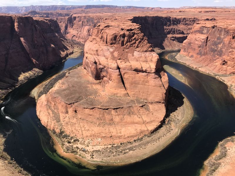
Horseshoe Bend
Two hours north, we pulled into Glen Canyon National Recreation Area to see Horseshoe Bend.
The transition is wild: you drive through miles of seemingly empty desert highway, turn into a corner, and suddenly find a massive parking lot packed with cars. It is one of the most photographed spots in the American Southwest, and the world knows it.
There was a little bit of a walk on a trail to get to the edge, but it wasn’t long, but not short like just get out of your car for a view. The view of the Colorado River wrapping perfectly around the orange canyon walls 1,000 feet below is undeniable. However, getting that iconic shot without a stranger’s head in it is a challenge!
Phone cameras back in 2021 didn’t always have the ultra-wide lens capability needed to fit the entire loop into the frame from the safety rail. It’s a single-purpose stop: walk up, take in the sheer scale, snap a photo, and hit the road.
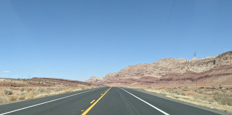
We continued north towards Utah, passing Lake Powell — the reservoir was noticeably low, the bleached white “bathtub ring” on the canyon walls telling the story of how far the water level had dropped — and on to Kanab.
Toadstool Hoodoos (Grand Staircase-Escalante)
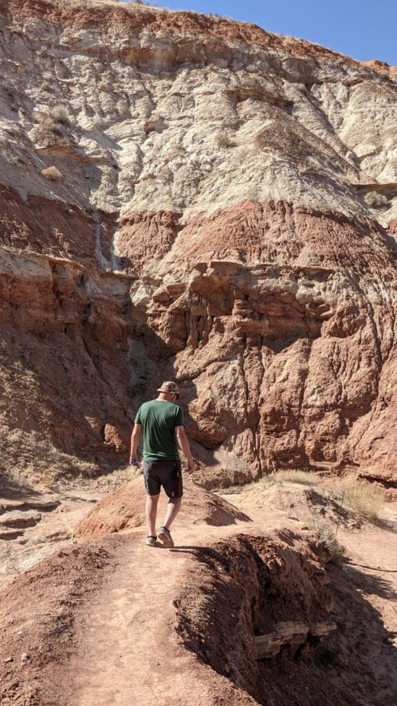
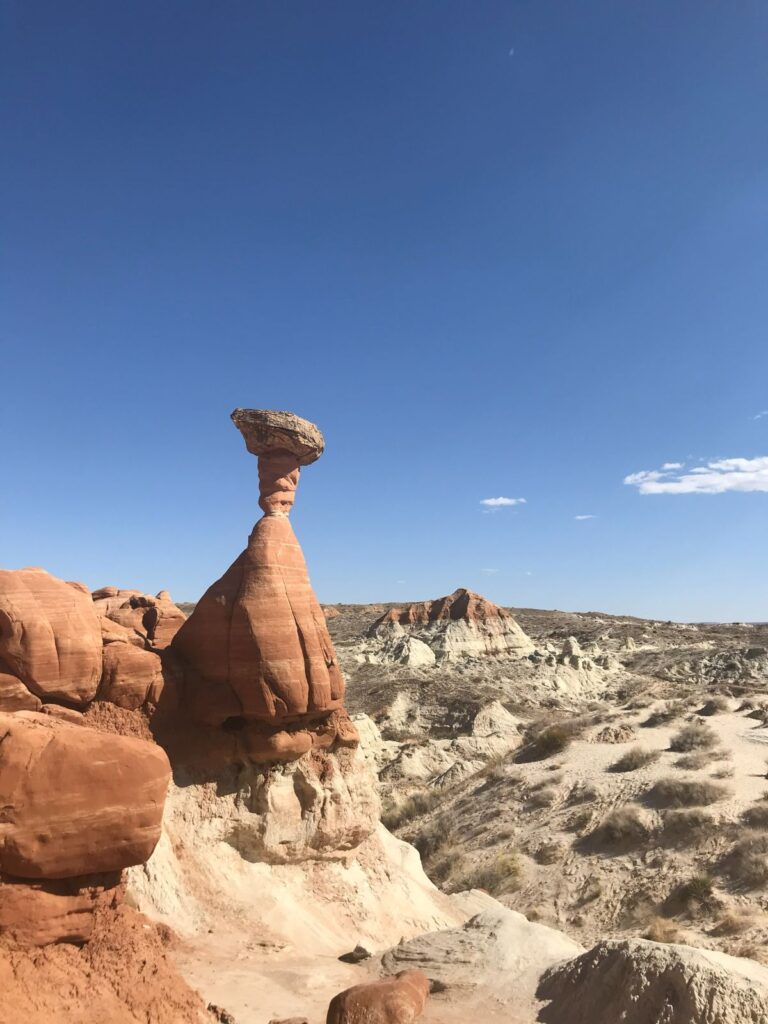
About 45 miles east of Kanab, just after crossing into Utah, we pulled off Highway 89 for a quick hike at the Toadstool Hoodoos—and it was a spectacular surprise.
The hike itself is easy and short, a 1.8-mile out-and-back trail that takes around 38 minutes on average. But what you find at the end is otherworldly. These “toadstools,” or hoodoos, form because Dakota Sandstone boulders perch atop pedestals of softer Entrada Sandstone. As the Entrada erodes away, the harder Dakota forms a cap, leaving a rock column sheltered from water and wind — the result looks exactly like a field of giant stone mushrooms scattered across a Mars-like desert landscape.
However, the landscape can get confusing once the defined trail thins out…
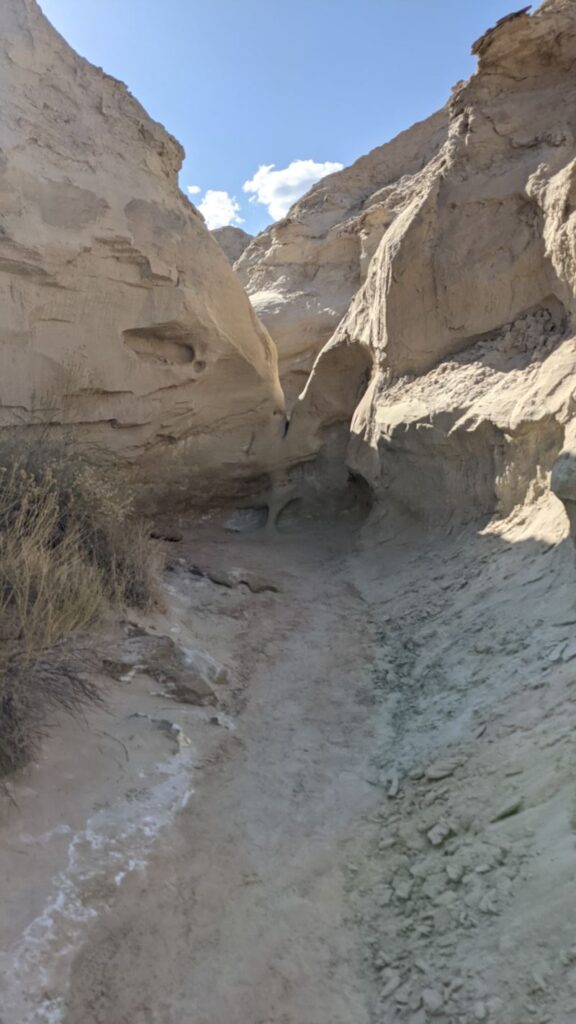
While exploring the formations, we made the mistake of following some other visitors who had wandered off-trail. I ended up getting myself wedged into a narrow rock cone and completely panicked.
The only exit was a 5-to-6-foot jump down onto the sand. Justin hopped down easily, but I stood frozen at the top hesitating for nearly 20 minutes while we tried to figure out a way to pull me back up. Ultimately, I just had to take the leap. It turned out to be completely fine, but it was a stark reminder: Stay on the designated trail and don’t blindly follow where others wander!
Despite the brief rock drama, this free, quick stop was the perfect, crowd-free way to decompress before finally rolling into Kanab.
It sits right off the highway with a small parking area — there are no fees to visit, and the trail is open year-round. It’s the kind of stop that takes less than an hour and delivers completely disproportionate payoff. A perfect way to decompress after Horseshoe Bend’s crowds before rolling into Kanab.
What We Missed: The North Rim of the Grand Canyon
We looked into making the North Rim a stop on our travel day to Kanab, but it wasn’t opening for the season for another three days or so — we just barely missed it. I’ve been to the Grand Canyon two or three times, but never the North Rim, and from everything I’ve read it’s a completely different experience — quieter, more forested, and arguably more dramatic in some ways. It’s on the list for next time.
Note: The North Rim typically opens mid-May and closes mid-October due to snow. If you’re planning a visit, check NPS.gov for current opening dates before routing through.
Flagstaff Itinerary Summary
| Day | What We Did |
|---|---|
| Day 1 = Day 13 on longer trip | Drive from Bisbee · Breakfast in Prescott (family visit) · Sedona (briefly) · Petrified Forest National Park · Dinner in Winslow, AZ |
| Day 2 = Day 14 on longer trip | Driving Range · Around town · Dark Sky Brewing · Flagstaff Brewing Company |
| Day 3 = Day 15 on longer trip | Tuzigoot National Monument · Route 66 drive to Williams · Grand Canyon Brewing Company · Historic Brewing Barrel & Bottle House |
| Day 4 = Day 16 on longer trip | Walnut Canyon National Monument · Navajo Bridge · Horseshoe Bend · Toadstool Hoodoos · Arrive Kanab, UT |
Practical Tips
- Sedona: Go early or book parking in advance — it gets overwhelmingly crowded on weekends and holidays.
- Petrified Forest: Don’t rush through the first half. That’s where the good stuff is.
- Winslow: Underrated stop. Budget at least an hour, grab a meal.
- Tuzigoot: Budget a couple of hours — visit the museum first, then walk the ruins. The valley views from the top are worth the climb alone. Entry also covers Montezuma Castle.
- Walnut Canyon: Right off I-40 east of Flagstaff — a perfect add-on if you’re passing through. The Island Trail is short but steep (240 steps down and back up), so wear real shoes.
- Horseshoe Bend: Go early if you can — the parking lot fills fast and the overlook gets crowded quickly. Bring an ultra-wide lens or use your phone’s wide-angle mode. It’s a short walk from the lot, but there’s no shade, so sun protection matters.
- Toadstool Hoodoos: Free, easy, right off Highway 89 — don’t skip it. Under an hour and completely worth it.
- North Rim timing: Check NPS.gov — it opens mid-May, so spring travelers may miss it.
- America the Beautiful Pass: Both national monuments and the Petrified Forest accept it. If you’re doing a longer Southwest trip, it pays for itself fast.
Up next: Kanab, Utah — the gateway to some of the most otherworldly landscapes in the American West. Previous was Bisbee, AZ.